 Filter: Categories of Wisconsin Historical Images
Filter: FULL_DATE of 1847
Filter: Categories of Wisconsin Historical Images
Filter: FULL_DATE of 1847

| Date: | 1847 |
|---|---|
| Description: | Engraving of the McCormick Reaper Works as it appeared in 1847. The factory was located on the north bank of the Chicago River, east of the Michigan Avenue... |
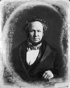
| Date: | 1847 |
|---|---|
| Description: | Quarter-length studio portrait of Henry Rowe Schoolcraft. |

| Date: | 1847 |
|---|---|
| Description: | An artists rendition of the western view of the Thiensville mills from the local tavern. Caption reads: "West View of Thiensville Mills from the Tavern." |

| Date: | 1847 |
|---|---|
| Description: | An unhappy looking bride is seated in a chair looking out the window as another woman sits on the floor holding her hand. A third woman looks on angrily. |

| Date: | 1847 |
|---|---|
| Description: | A woman sits at a table reading while apparently neglecting her whole family. |

| Date: | 1847 |
|---|---|
| Description: | Baby mittens knitted of ecru, red and pink wool yarn. |

| Date: | 1847 |
|---|---|
| Description: | Drawing of a Native American man looking into the Milwaukee settlement. |

| Date: | 1847 |
|---|---|
| Description: | Distant view of the early settlement of the town showing a strip of low-slung buildings in a barren expanse. |

| Date: | 1847 |
|---|---|
| Description: | A color map of Kentucky with insets showing Lexington, the Falls of Ohio, and the Ohio River. |

| Date: | 1847 |
|---|---|
| Description: | In 1847, a year before Wisconsin entered statehood, most of the county shapes in southeastern and southern Wisconsin looked the same as they do today, wher... |

| Date: | 1847 |
|---|---|
| Description: | A hand-colored map that shows the area south and east of the Wisconsin and Fox Rivers, as well as a few landmarks just north of that area. The township gri... |

| Date: | 1847 |
|---|---|
| Description: | A geological, hand-colored map of Wisconsin north and west of the Wisconsin River, as well as portions of eastern Minnesota and Iowa from the Mississippi t... |

| Date: | 1847 |
|---|---|
| Description: | Shows parts of northeastern Iowa County, northwestern Dane County, and the extreme southern part of Sauk County "shewing the position of the British Temper... |

| Date: | 1847 |
|---|---|
| Description: | This map shows lot and block numbers, roads, railroads, and some landowners’ names. Lake Michigan, the Milwaukee River, and the Menomonee River are labeled... |

| Date: | 1847 |
|---|---|
| Description: | This map identifies surveyed areas of the Upper Peninsula and shows lakes, rivers, and islands in portions of Wisconsin, Minnesota, Michigan, and upper Can... |

| Date: | 1847 |
|---|---|
| Description: | This hand-colored map shows area north and west of Wisconsin River and south and east of Saint Louis and upper Mississippi Rivers. |

| Date: | 1847 |
|---|---|
| Description: | Ninth plate ferrotype/tintype. Three-quarter length portrait of Henry A. Cooper, as a young boy, standing in front of a backdrop. He is wearing a military... |

| Date: | 1847 |
|---|---|
| Description: | Ninth plate ferrotype/tintype quarter-length profile portrait of Reverend C.J. Hendley. Episcopal clergyman. Married to Jane Olive Kimball, July 20, 1865 i... |

| Date: | 1847 |
|---|---|
| Description: | Sixth-plate daguerreotype. Waist-up portrait of an unknown man sitting in a chair. He is holding a cane in one hand, and is wearing a suit coat, vest, and ... |
If you didn't find the material you searched for, our Library Reference Staff can help.
Call our reference desk at 608-264-6535 or email us at:
